 TimeMaps is historical maps software, just unveiled today, by our friends at KnowledgeQuest Maps! These interactive, animated maps are so informative and so user-friendly. I’m having fun playing with them tonight, since our children are all at various practices.
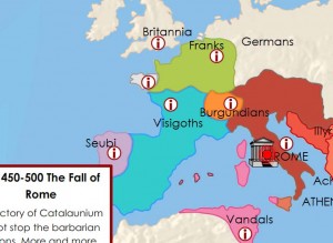
Since we are studying Rome currently and nearing its Fall, that is the first map set I opened. The first map in the sequence outlines the Roman Empire at its height, in 182 A.D., with plenty of key locations labeled. Several information buttons scattered across the map (when you click the main ‘I’ button,) provide pop-up historical data on the key places and peoples of the time, as you click each. To check your attentiveness to the information and the map, you can click another button to ask you questions about that map.
Another click and the map shows the next stop in history for this map, in this case 225 A.D. Animation shows invasions, and loss of territory, (or progress, travels, and other movement on other maps). You don’t just have a new different map, but you actually see the changes that happen between the two! Try that on your paper maps. 🙂
These 3 factors make these maps very engaging – historical information at a click, animation when you change maps to show you what is changing, and the questions to ensure you “got it”.
The map program itself is very intuitive, and only after I’d already gone through the whole map set for the Fall of the Roman Empire, did I open the included Notes pdf file, which includes instructions for using the maps. But this document includes more than just that.
In addition to the instructions, several suggested activities for further learning about the time period are included. These activities encourage deeper critical thinking, requiring the student to reason out the answers. You can pick and choose which ones will be appropriate for which of your children.
Also included in the Notes document is a Commentary on the Map, giving background information and details for each map in the sequence, at 2 levels. You decide how deep you want to share about each map with your students, a short overview or more in-depth information with further questions for your students.
But that still isn’t all. You can print out a Timeline for the Student to fill in, a Student’s map for them to label/color, and a Teacher’s Map (filled out correctly.)
And just when I thought I was done, I realized there were still 2 buttons I hadn’t clicked on at the beginning of the maps. In addition to the Start button, which takes you through the map sequence, there is a button called Worksheets will show you the activities (that are also included in the notes, that you could print out). The other button takes you to the TimeMaps of World History website, where you can explore an online Atlas of World History.
TimeMaps is much more than just a historical sequence of maps for your students to view on a computer, it provides the information, activities and questions needed to get your students thinking about what they are seeing on the maps, and what really happened in HisStory. TimeMaps is jam packed full of value! I look forward to sharing the Rise of the Roman Empire set with my children in tomorrow’s lessons. The other map sets currently available are: Ancient China, Rise of Islam, The Black Death, European Exploration, and Atlantic Slave Trade. Introductory price is 7.95 each. Available for both Windows and Mac computers.


 Answers in Genesis is offering one of their audio downloads, in their store, for FREE – this week only.
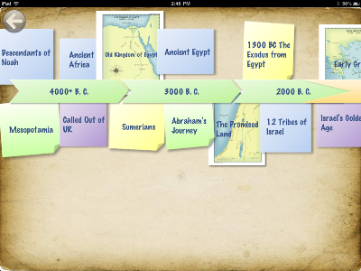
  Nothing puts history in context like a timeline. And nothing makes a timeline more helpful than awesome visuals. Wonders of Old is a beautiful, new Timeline Book of World History. This timeline in colorful pictures is divided into streams for the different areas of the world. Wonders of Old:Ancient Timeline, that I received for review, covers time from Creation to the end of the Roman Empire. Tapping on a label (event with date) will bring up additional information about it. Tapping on a picture will bring up the wikipedia page for it. Swiping will move you down the timeline horizontally (forward in time), or to another part of the world (at the same time,) vertically. This is a thorough, informative and gorgeous timeline app. Whether you are using it along with your history studies, or you’re just swiping and tapping around to learn a variety of new things, you’ll enjoy this app. Even my dad said, “Now this is the kind of app I’d like.” It will provide hours of fun learning. The second app in this series, Wonders of Old:Medieval Timeline, was just released. It continues where Ancient leaves off and goes through the 16th century. There will be 4 apps in this series, when they are completed.
 Geography should be studied right alongside of history, so you can see where things happened and get a better understanding of them. The Map Trek app is the perfect companion to Wonders of Old to do just that, and it works in much the same way. It too is divided into 4 timeperiods—with just the first, Ancient, currently available. Along the (more simplified) timeline are labels (and some map pics) of key happenings. Tap the label and a map of the event opens up. The maps are clearly labeled and have drop pins at points of interest. Tap a pin and information about the location, related to the event, opens up. You can pinch and spread to zoom in and out. These interactive maps can be used along with your pen and paper mapwork you do for your journals, or as a standalone enrichment activity.


